


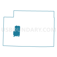
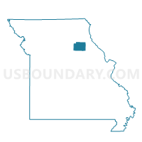
Holiday 9 Voting District, Monroe County, Missouri
About
Outline

Summary
| Unique Area Identifier | 609160 |
| Name | Holiday 9 Voting District |
| County | Monroe County |
| State | Missouri |
| Area (square miles) | 20.92 |
| Land Area (square miles) | 20.83 |
| Water Area (square miles) | 0.10 |
| % of Land Area | 99.54 |
| % of Water Area | 0.46 |
| Latitude of the Internal Point | 39.47612770 |
| Longtitude of the Internal Point | -92.15226960 |
Maps

Graphs
Select a template below for downloading or customizing gragh for Holiday 9 Voting District, Monroe County, Missouri


Neighbors
Neighoring Voting District (by Name) Neighboring Voting District on the Map
- Duncans Bridge 7 & 8/Madison 10 & 11 Voting District, Monroe County, MO
- Granville 6/Paris 14 & 15 Voting District, Monroe County, MO
- Paris Rural 16 Voting District, Monroe County, MO
- Union 12 & 13 Voting District, Monroe County, MO
Top 10 Neighboring County Subdivision (by Population) Neighboring County Subdivision on the Map
- Jackson township, Monroe County, MO (2,416)
- Marion township, Monroe County, MO (1,363)
- Union township, Monroe County, MO (850)
- Clay township, Monroe County, MO (301)
- Woodlawn township, Monroe County, MO (222)